


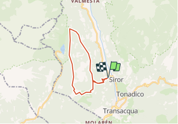
Siror Val serena Col Santo

ARPF
User

Length
10.7 km

Max alt
1816 m

Uphill gradient
1092 m
Km-Effort
25 km

Min alt
799 m

Downhill gradient
1091 m
Boucle
Yes
Creation date :
2019-01-15 12:11:13.888
Updated on :
2019-01-15 12:11:13.888
12m
Difficulty : Medium

FREE GPS app for hiking
 SityTrail
IGN / Geographical institutes
SityTrail Plus
The world is yours!
About
Trail Walking of 10.7 km to be discovered at Trentino-Alto Adige/Südtirol, Provincia di Trento, Primiero San Martino di Castrozza. This trail is proposed by ARPF.
Description
montée depuis Siror vers le col Santo et le Spiz del Doch et retour par Bédolé
Positioning
Country:
Italy
Region :
Trentino-Alto Adige/Südtirol
Department/Province :
Provincia di Trento
Municipality :
Primiero San Martino di Castrozza
Location:
Unknown
Start:(Dec)
Start:(UTM)
718023 ; 5118970 (32T) N.
Comments